
Hippodamus in the Pampas
Maybe we spend too much effort arguing about the formal merits or shortcomings of the urban grid without paying enough attention to other questions. For example, its succinct way of setting the table for the urban game of public and private.
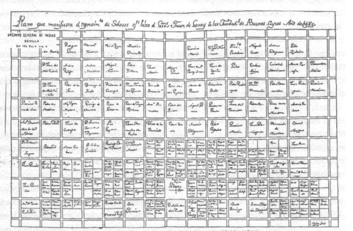
Take for example the case of Buenos Aires. When Juan de Garay founded the city in 1580 (see note) he distributed land on a regular square grid roughly 130 by 130 meters. Inside the squares private property, outside public. Nothing earthshaking about that. Now the game begins.
First, Garay removes one of the squares and labels the empty space "Plaza". That becomes public. In many Spanish colonial cities the main square is at the center (why elsewhere?) but in Buenos Aires it's almost (but not quite!) on the eastern margin, a block, a little bit more than a block to be precise, from the edge of the river. What was an even pattern now has acquired not only a hierarchy but also orientation. The grid has been articulated anchored both socially and geographically. Some manzanas--as the blocks are called in Buenos Aires--are more central and more valuable so those are subdivided in quarters. You can see it in the map: the denser manzanas bunch up around the Plaza and along the coast, while some of the ones farther away are not even worth labeling.
And over time the game will continue. Blocks will be further subdivided, other squares will appear, some streets will be widened, diagonals will slice through the grid... but that another story (or many.)
Note: Yes, Buenos Aires had an earlier incarnation. Founded by Pedro de Mendoza in 1536, it was abandoned within five years under the most harrowing of circumstances (best depicted in a little drawing by the Bavarian chronicler Ulrich Schmidl and in the first chapter of Manuel Mujica Lainez's exquisite "Misteriosa Buenos Aires".)